
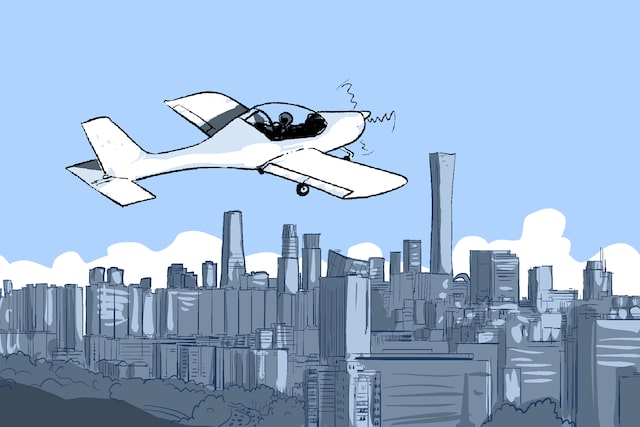
A light aircraft crashed into a high-rise building in central Beijing on June 26, killing the pilot and injuring 13 people not on board.Authorities said a single-engine, two-seat light sport aircraft collided with a high-rise building near Beijing’s East Third Ring Road at 5:55 p.m. local time, but have released few details about the circumstances surrounding the crash.More than a week later, many questions remain unanswered. Chinese authorities have not explained how the aircraft entered airspace near one of the country’s most heavily controlled and politically sensitive areas.Questions about the identity of the pilot swirled in the aftermath, only being confirmed by authorities almost a week after the crash.An investigation is under way.People point their mobile phones at CITIC Tower, also known as China Zun, where damage is visible on a high floor of the exterior, in Beijing, China on June 26, 2026. REUTERS/Maxim Shemetov. The damaged exterior of CITIC Tower, also known as China Zun, in Beijing. REUTERS/Maxim Shemetov.The damaged exterior of CITIC Tower, zoomed in to show the damage to the glass exterior. REUTERS/Maxim Shemetov
What is known about where it happened
Chinese authorities said only that a light aircraft struck a high-rise building in Beijing’s Chaoyang district near the East Third Ring Road. Their statement did not identify the building.Reuters identified the location as CITIC Tower, also known as China Zun, through images, videos and reporting from the scene. The 528-metre (1,732-foot) skyscraper is Beijing’s tallest building and dominates the capital’s central business district. Beijing municipal government did not reply to a request for comment about the identity of the building.The crash showed damage high on the building’s glass facade, where two large exterior panels were destroyed.
CITIC Tower
528m high
108-storeys
~1,700 feet
Approximate location of crash on eastern facade
CCTV
Headquarters
A hazy city skyline with modern skyscrapers rising above a tree-lined foreground. The tall CITIC Tower dominates the centre, annotated “CITIC Tower 528m high, 108-storeys ~1,700 feet,” with a marked circle noting “Approximate location of crash on eastern facade.” Nearby buildings include “CCTV Headquarters.” Soft morning light and blue-grey smog create low contrast, partially obscuring mid-ground buildings.Flight tracking data reviewed by Reuters shows the aircraft’s final recorded altitude was about 2,800 feet before tracking ended in Chaoyang district. That places the aircraft about 1,000 feet above the roof of CITIC Tower, which rises more than 1,700 feet above the city.While the exact point of impact has not been officially disclosed, publicly available imagery and photos captured by Reuters places the damage on the upper floors of the tower.
Plane last recorded 6km from CITIC Tower
Data from Flightradar24 reviewed by Reuters showed aircraft B-12PP departing from Beijing’s Shifosi airport before flying west towards downtown Beijing.Tracking ended in Chaoyang district, with the aircraft’s final recorded position just over 6 km from CITIC Tower.
Final flight path
Beijing Capital International Airport
Beijing Shifosi Airport
First tracked position
5:27 p.m.
Beijing
Forbidden City
Crash site 5:55 p.m
Path of the aircraft
Final tracked position
5:55 p.m.
5 km
Map titled “Final flight path” showing Beijing in pale grey. A red line traces an aircraft route from “Beijing Shifosi Airport” (first tracked 5:27 p.m.) westward to a “Crash site 5:55 p.m.” near “Forbidden City.” “Beijing Capital International Airport” is marked; scale 5 km.The final point recorded by flight-tracking services does not necessarily represent the exact location of a crash. It is quite common for aircraft to lose signal.Flightradar24 builds flight paths using data from a network of public and private receivers, and aircraft can disappear due to multiple factors, including altitude, signal quality or reception limitations.Reuters has reported only the last recorded position available from Flightradar24 data and cannot independently verify the aircraft’s route after that point.There is also an apparent discrepancy between the official crash time provided by authorities — 5:55 p.m. local time — and the final tracking point available from Flightradar24, with both listing the same time despite the plane being over 6km away from the tower.However, by estimating the last recorded ground speed of the aircraft and the distance to the location of the crash, it is possible the plane could have reached the location within minutes of its last recorded location. Beijing municipal government did not reply to a request for comment about the timing discrepancy.
Plane could have reached tower from last recorded point
Estimating the travel distance based on the last recorded ground speed of 191km/h, the plane could have reached the tower within 2 minutes. This could have been earlier or later if the plane increased or decreased its speed.
Chaoyang Park
6.4 km (2 minutes)
Forbidden
City
CITICTower
3.2 km (1 minute)
Tian’anmen
Square
1.6 km (30 seconds)
Temple of
Heaven
Last recorded signal
5:55:31 p.m.
Estimated travel distance assuming the aircraft maintained a ground speed of approximately 191 km/h.
N
2 km
Map titled “Plane could have reached tower from last recorded point” showing central Beijing. A red track ends east of CITIC Tower at “Last recorded signal 5:55:31 p.m.” Concentric dotted rings (1.6 km/30s, 3.2 km/1 min, 6.4 km/2 min) radiate around this point and remain east of central landmarks, not extending past the Forbidden City.
What is known about the pilot and the plane
Initially, authorities confirmed only that there was one person on board and that the pilot died in the crash. They did not publicly identify the pilot or release any information about their experience, qualifications or the purpose of the flight until almost a week later.The pilot was later identified by Beijing’s Chaoyang district government as a 66-year-old man surnamed Liu. Liu, a Beijing native, had long suffered from insomnia and anxiety, and his diary repeatedly mentioned ending his life, the statement said. The incident was caused by “personal reasons,” it added.Without identifying the 108-storey CITIC Tower, headquarters of one of China’s largest state-owned conglomerates, the Chaoyang government said Liu had deviated from his approved flight area and lost contact with the airport from which he took off before crashing into the building and dying at the scene.Flight tracking data identified the aircraft as a Sunward Aurora SA60L, a Chinese-made, two-seat, single-engine light sport aircraft. The stall speed of the aircraft is 72km/h according to information on the manufacturer’s website.
Cruise speed
220 kmh
4,200 kmh
Max. ceiling
Max range
1,200 km
Two seats
Pilot and co-pilot
6.9m
8.6m
Sunward SA60L Aurora
Infographic titled “Sunward SA60L Aurora” showing a small two‑seat propeller aircraft in side and top views. Text lists: “Cruise speed 220 kmh,” “Max. ceiling 4,200 km,” “Max range 1,200 km,” “Two seats Pilot and co‑pilot.” Dimensions marked: length 6.9 m, wingspan 8.6 m, with a human silhouette for scale.Images circulating on social media showed debris carrying the registration B-12PP, while promotional material reviewed by Reuters indicated the aircraft may have been operated by Beijing-based Dongshi Shuangyue General Aviation.A Dongshi Shuangyue General Aviation employee contacted by Reuters on Saturday said she was not sure whether B-12PP belonged to the company, without providing further information.The crash has also raised broader questions about China’s rapidly expanding low-altitude aviation sector. Reuters found that some scenic flight operators and aviation companies had suspended services following the incident while awaiting guidance from regulators. Industry participants reported uncertainty over whether additional restrictions would be imposed as authorities investigate the crash.Blaming the pilot does not explain the gaps in security, however. Internet users were still seeking answers in posts beneath the online statement before they were swiftly deleted.
Moments before crash, a near-miss
A Reuters review of Flightradar24 data showed that Hainan Airlines Flight 7146, an Airbus A330-300, was approaching Beijing Capital International Airport in the minutes before the light aircraft crashed into CITIC Tower.There was just over 1,000 feet difference between the two aircrafts in their altitudes before they crossed paths.Flight data for the Hainan Airlines aircraft also showed a sharp increase in altitude around the same time, indicating that it climbed while on approach. The aircraft subsequently performed a go-around before landing from the opposite direction to its original approach path. Beijing Capital International Airport and Hainan Airlines did not reply to a request for comment about the flight path of the Hainan Airlines flight.
Flight data reveals possible near-miss before crash
Flight-tracking data reviewed by Reuters shows a Hainan Airlines Airbus A330 carrying out a go-around as the Sunward Aurora SA60L crossed Beijing airport’s arrival corridor before continuing towards central Beijing.
05:51:11 p.m.
2,550 feet
Forbidden
City
CITICTower
Tian’anmen
HU7146
Square
05:51:01 p.m.
3,775 feet
Last recorded signal
5:55:31 p.m.
N
5 km
B12PP
Map titled “Flight data reveals possible near-miss before crash” shows Beijing. A red track to CITIC Tower contrasts with a blue path of flight HU7146, with timestamps and altitudes, highlighting proximity near the arrival corridor.The light aircraft continued flying westward towards central Beijing after crossing the approach paths.Source Flightradar24
Edited by Ryan Woo, Rebecca Pazos, Anton Slodowski and Raju Gopalakrishnan.